


The abandoned settlements Mull and Ulva offer a fascinating glimpse into Scotland’s past, from the dramatic Highland Clearances to centuries-old village life. Scattered across rugged landscapes and coastal shores, these deserted villages tell stories of families, communities, and traditions that have long since vanished. Exploring these ruins not only reveals the island’s rich history but also provides a unique insight into the cultural and social changes that shaped Mull and Ulva over time.
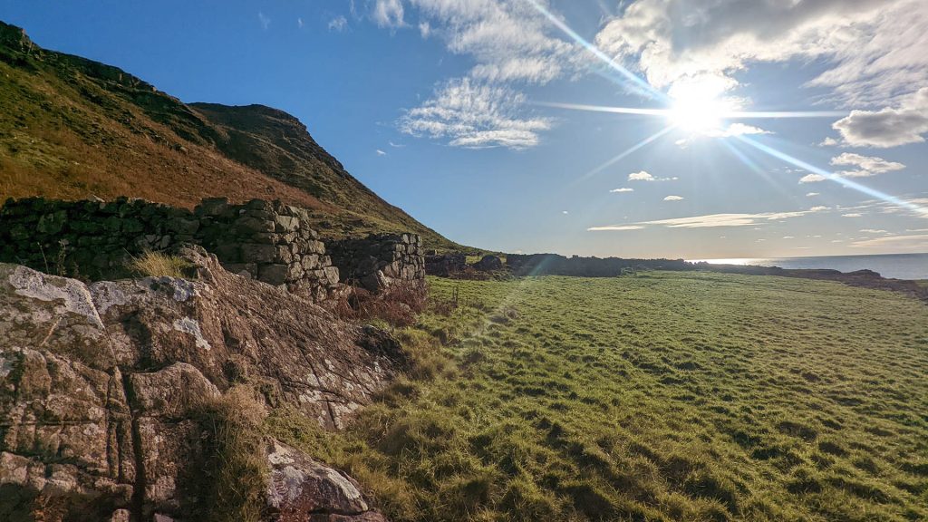
Ardmeanach & Treshnish Coast (West / NW Mull)
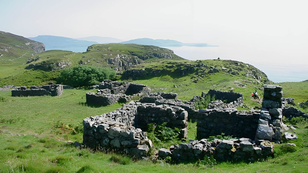
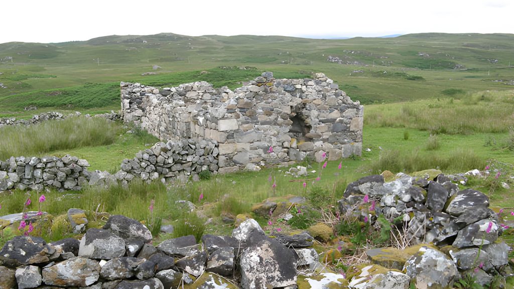
Crackaig (Cracaig)
Location: Treshnish coast, west Mull.
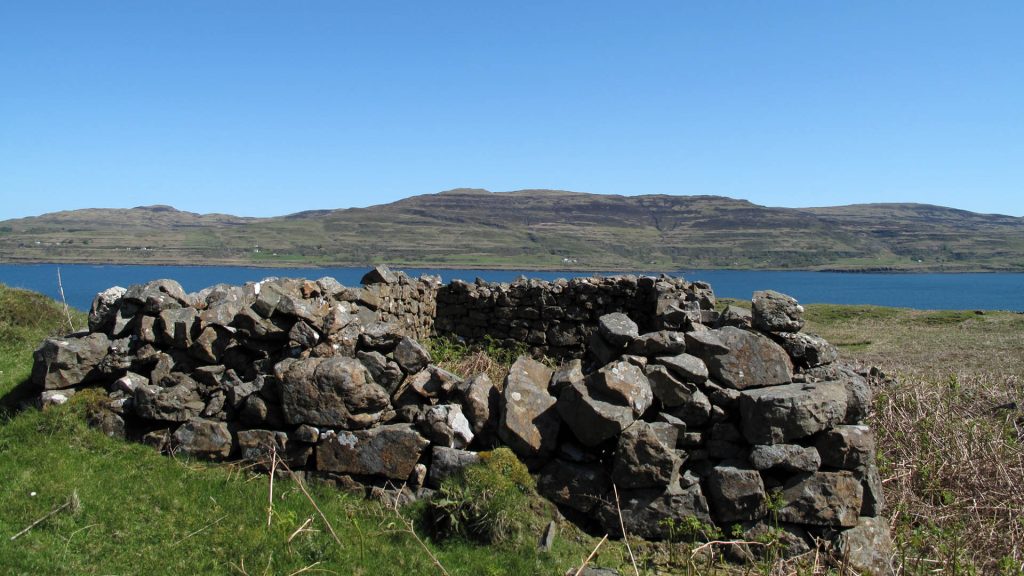
Crackaig is one of the best-preserved deserted townships on Mull’s rugged Treshnish coastline. The remains include the roofless shells of around fifteen longhouses, clustered across a slope above the sea. Archaeological survey has revealed an extensive layout of dwellings, enclosures, and trackways, demonstrating the size of the community and its reliance on mixed farming and the sea.
The township was cleared in the 19th century during the upheavals of the Highland Clearances. Families were displaced, and the land was absorbed into large-scale sheep farming. Today, Crackaig forms part of a scheduled monument and is a powerful reminder of the human cost of clearance on the island.
Glac Gugairidh
Location: Adjacent to Crackaig, Treshnish coast, west Mull.
Glac Gugairidh lies just inland from Crackaig and is often paired with it as a linked township. The settlement was smaller but shows the same pattern of longhouses, cultivation plots, and boundary walls. Together, the two sites illustrate how families lived side by side in cooperative yet distinct communities.
The land was also cleared in the 19th century, leaving behind the low outlines of walls and dwellings. The site’s scheduling ensures its protection, and today walkers can still trace the patterns of daily life frozen in stone and turf.
Burg
Location: Ardmeanach peninsula, west Mull.
The township of Burg lay near the famous fossil tree on the Ardmeanach peninsula. Its remains consist of multiple houses and traces of cultivation. The people of Burg would have lived by farming and by using the natural resources of the wild coastline.
The community was ultimately abandoned, and today only ruins remain. Its remote setting ensures it is little disturbed, leaving a strong sense of atmosphere for visitors who make the long walk to Burg.
Culliemore
Location: Near Tavool House, Ardmeanach, west Mull.
Culliemore was a small settlement near Tavool House. The remains of croft houses and enclosures show its role as part of a wider rural community on the peninsula. Like others, it was cleared in the 19th century, ending centuries of habitation.
The ruins are now absorbed into estate land but can still be traced by careful walkers. They speak of the scattering of communities that once dotted Ardmeanach’s rugged slopes.
Calgary Area (Northwest Mull)
Inivea
Location: Above Calgary Bay, northwest Mull.
Inivea overlooks Calgary Bay and is one of the most evocative abandoned villages on Mull. Archaeologists have identified around two dozen structures, including houses, byres, and small enclosures. Its commanding location shows how the inhabitants farmed the hills while benefiting from access to the sea below.
The village was cleared in the early 19th century as part of wider estate changes. The ruins are now grass-grown but still clearly visible. Today, Inivea forms a poignant backdrop to one of Mull’s most visited landscapes, with the ruined homes gazing down on the famous white sands of Calgary.
Kildavie
Location: Langamull, northwest Mull.
Kildavie, known in Gaelic as Cill da Bhidhe, is a deserted township located in the Langamull area of northwest Mull. Situated on a fertile plateau by the Cill da Bhidhe river, the settlement was inhabited until at least 1785. Its desertion predates the main Highland Clearances, likely due to factors like climate, crop failures, or early estate changes.
Since its rediscovery, the site has been studied by archaeologists, revealing structures, pottery, and a possible mill. Today, Kildavie is preserved within the NW Mull Community Woodland and can be reached on foot, making it one of the island’s richest archaeological landscapes.
Glen Forsa & North-Central Mull
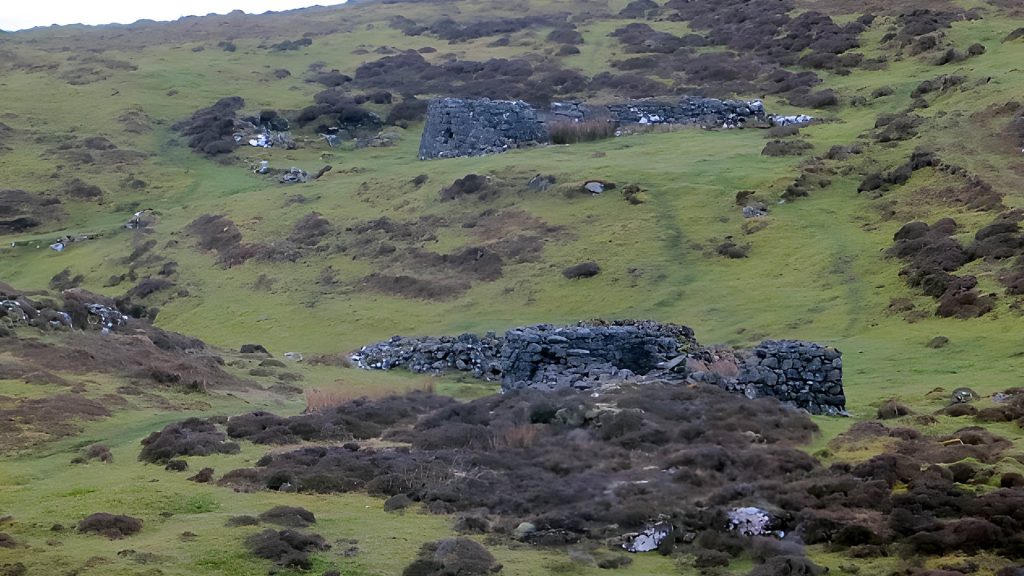
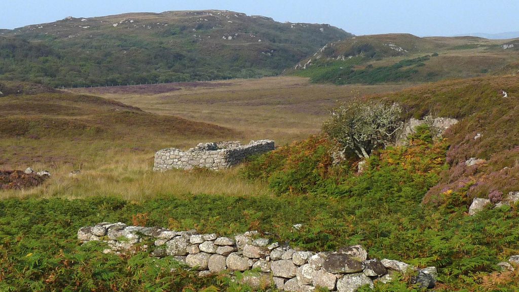
Rhoail (Glen Forsa)
Location: Glen Forsa, central Mull.
Rhoail sits on the wide valley floor of Glen Forsa, where about a dozen roofless buildings survive. The settlement was based around small-scale farming, with access to fertile arable ground and grazing along the glen. Its ruined longhouses, scattered enclosures, and field systems give a clear impression of everyday life in the Highlands before clearance.
Depopulated in the 18th or 19th century, Rhoail is now a haunting site for walkers exploring Glen Forsa. With Ben Talaidh towering to the south, the contrast between the natural grandeur and human loss is particularly strong here.
Killiemor (Cille Mhoire)
Location: North Mull.
Killiemor, also known as Cille Mhoire, was a substantial settlement with around twelve roofless houses still traceable today. It lay in fertile ground that supported a thriving community for centuries. The arrangement of houses suggests a nucleated village, with families clustered close together.
It was eventually abandoned in the 19th century. Today, the low stone walls and foundations stand as mute testimony to a once lively village, now reclaimed by grass and bracken.
Rairaig
Location: Glen Forsa area, north-central Mull.
Rairaig is a smaller deserted settlement in north Mull. Although less prominent than its neighbours, it retains the foundations of croft houses and agricultural plots. Its position within Glen Forsa suggests that it once contributed to the valley’s thriving crofting community.
Like many of its contemporaries, Rairaig was depopulated during the Clearances. Today its stone outlines are softened by the landscape, but they remain as a quiet reminder of those who once lived there.
Ross of Mull
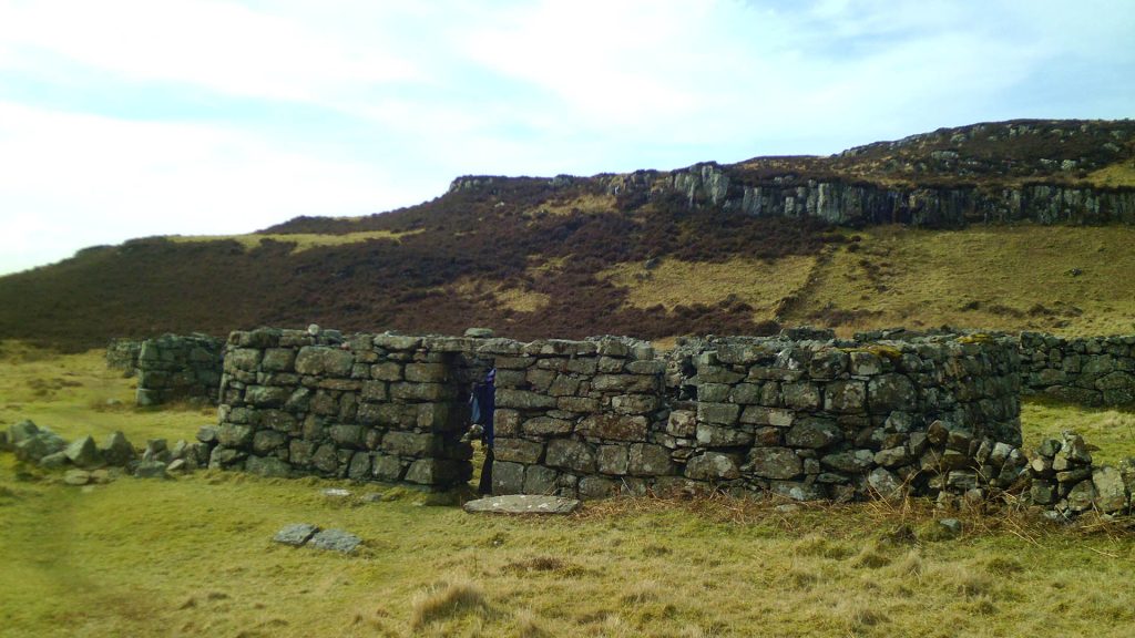
Shiaba
Location: South coast of the Ross of Mull (Ross of Mull peninsula), Isle of Mull.
Shiaba is a well-documented deserted township on the south coast of the Ross of Mull. It preserves extensive remains of longhouses, corn-drying kilns, horizontal watermills and run-rig field systems that record the transition from pre-crofting agriculture to later crofting economy. The site was designated a Scheduled Monument in the 1990s because of its national importance for understanding 18th– and 19th–century rural life on Mull.
Clearance of Shiaba began in the mid-1840s, with most residents evicted by 1847 after successive hardships including potato failure; some inhabitants emigrated while a small number remained as shepherds into the later 19th century. The ruins remain highly visible in the landscape and are frequently studied and visited as a key example of Highland clearance-era settlement and abandonment.
Knocknafenaig
Location: Ross of Mull, near Carsaig and south of Bunessan.
Knocknafenaig is one of the best-preserved deserted settlements on the Ross of Mull. Its ruins, including longhouses, outbuildings, a well-preserved corn-drying kiln, and the prominent “Braigh House,” illustrate a community that relied on mixed farming and shared resources.
The substantial Braigh House suggests there were social differences within the township. The settlement was gradually abandoned during the 19th-century Clearances, with residents being displaced or emigrating. Today, the atmospheric ruins of Knocknafenaig are a Scheduled Monument, valued for the clarity with which they demonstrate the architecture of a cleared township.
Suidhe (Suie)
Location: Ross of Mull, inland from the coast road between Bunessan and Fionnphort.
Suidhe, also recorded as Suie, is a deserted township on the Ross of Mull. The site preserves the foundations of longhouses, byres, and associated field systems spread across a gentle slope. Its elevated position provided wide views across the surrounding landscape and access to both grazing and arable land. The remains give a clear impression of the size and organisation of the community before its abandonment.
The township was deserted during the 19th century, most likely in the course of the Highland Clearances. Archaeological survey has recorded the outlines of the settlement, and in 2004 it was designated a Scheduled Monument due to its importance in illustrating crofting life on Mull. Today, the ruins at Suidhe stand as a quiet but evocative reminder of the depopulation that transformed the Ross of Mull.
Breac-achadh
Location: Ross of Mull, inland from the Bunessan area.
Breac-achadh, whose name translates roughly as “speckled field,” was once a small but active crofting township on the Ross of Mull. The remains consist of several longhouses and outbuildings, accompanied by traces of enclosure walls and run-rig cultivation ridges. The site illustrates the typical scale of settlement in this part of the island, where a handful of families worked small plots of land in close proximity to each other.
The township was abandoned in the 19th century, likely during the wider Clearances that swept through the Ross of Mull. The stone walls of its dwellings now lie roofless and grass-covered, gradually blending back into the hillside. Despite their modest scale, the ruins at Breac-achadh are a poignant testament to the many small communities that once sustained life in this remote region of Mull.
Cille Mhuire
Location: Ross of Mull.
Cille Mhuire was a small rural community now remembered only in its ruins. The site shows the remains of longhouses and field systems, typical of Ross of Mull crofting townships. Its name, referencing a church dedication, suggests a long history of habitation.
Depopulated during the 18th and 19th centuries, it is now a quiet ruin. The site demonstrates how even the smallest settlements were subject to the sweeping changes of the Clearances.
Dererach
Location: Ross of Mull.
Dererach is known both for its settlement remains and for the discovery of a bronze axe in its vicinity, linking the area to far older human activity. The township itself was abandoned in the 19th century, but its ruins include several structures and field systems.
Its dual significance as both an archaeological and historical site makes Dererach an intriguing place to study the continuity of settlement on the Ross of Mull.
Northeast Mull
Balgamrie
Location: Northeast Mull.
Balgamrie was one of a pair of deserted settlements in the northeast of Mull. The remains show houses, field systems, and signs of cultivation. Its location suggests a small but active crofting community.
The settlement was abandoned in the clearance period, with families forced to leave their homes. Today, the foundations are visible as grassy humps and walls, telling of a once-busy life on Mull’s eastern side.
Barnashoag
Location: Northeast Mull.
Barnashoag lay close to Balgamrie and was likely connected socially and economically. The site preserves the outlines of croft houses and enclosures, forming a complementary picture with its neighbour. Together they reveal a wider pattern of settlement in the area.
Abandoned during the Clearances, Barnashoag survives as low ruins in the landscape. Its pairing with Balgamrie highlights the clustering of small communities across Mull before the 19th-century upheavals.
Ulva
Ormaig
Location: North coast of Ulva.
Ormaig was a substantial township on Ulva’s northern shore. Its houses and byres formed a close-knit community that lived by crofting, fishing, and kelp work. The scale of the ruins indicates a thriving village before clearance.
The site was abandoned in the 19th century. Today its gables and walls remain, set against the backdrop of the sea. Ormaig is one of Ulva’s most striking deserted villages.
Cragaig (Craigaig)
Location: Southeast Ulva.
Cragaig lies near the island’s southeast, with remains scattered across the fields. The ruins include longhouses, enclosures, and the traces of crofting agriculture. Today, a simple bothy nearby provides shelter to walkers, ensuring the name Cragaig lives on.
The township was cleared in the 19th century, displacing its residents. Its ruins, softened by grass and bracken, remain evocative reminders of Ulva’s once thriving population.
Culinish
Location: North Ulva.
Culinish was one of the island’s northern townships, positioned in fertile ground near the sea. It supported a cluster of families whose livelihoods combined farming and fishing. Archaeological traces show a mix of dwellings and agricultural plots.
The settlement was abandoned in the 19th century. Today, the low ruins mark the spot where a vibrant community once stood.
Aird Glass / “Starvation Terrace”
Location: Eastern Ulva, Ard Glass headland.
Aird Glass is remembered for the row of houses known as “Starvation Terrace.” Oral tradition holds that families evicted from elsewhere were forced to live here in desperate conditions, giving the terrace its grim name. The remains are still visible along the headland.
Though stark in name and memory, Aird Glass remains a hauntingly beautiful place to visit. Its ruins, set against sweeping sea views, encapsulate the hardship of the Clearances on Ulva.
Bearnus (Bernais)
Location: Ulva.
Bearnus, also known as Bernais, was once a small settlement whose remains can still be traced. The site contains the outlines of longhouses and small crofts, evidence of a subsistence community closely tied to the land.
The township was cleared during the 19th century. Although modest in scale, its ruins tell the same story of displacement experienced across Ulva and Mull.
Baile Ghartan (Baligartan)
Location: Ulva.
Baile Ghartan, or Baligartan, was a crofting settlement on Ulva. Its ruins include house footings and possible enclosures, set within rough grazing land. Families here would have lived from livestock, crops, and kelp work along the shore.
Depopulated in the 19th century, Baile Ghartan is now a quiet place of ruin. It reflects the widespread nature of clearance, reaching even the smallest corners of Ulva.
This book provides a full and engaging history of the islands from the time of their earliest human inhabitants to the present day. The gazetteer lists all the places of interest from all periods in the islands' history, from the world-wide renowned churches, crosses and grave slabs on Iona and the magnificent restored Duart Castle on Mull, seat of the clan Maclean, to the planned village of Dervaig, the townships in the Ross of Mull and Ardmeanach which were cleared during the nineteenth century and the mausoleum of Lachlan MacQuarrie, the much esteemed 18th-century Governor of New South Wales.
Eolasary
Location: Ulva.
Eolasary was another of Ulva’s crofting townships, now reduced to stone ruins. It lay on fertile land and once supported a handful of families. The remains are faint but can still be located in the landscape.
Like its neighbours, it was abandoned during the Clearances. Its name survives in oral history and maps, preserving its memory.
Soriby
Location: Soriby Bay, Ulva.
Soriby was a settlement clustered around Soriby Bay. The location gave access to fishing grounds as well as crofting land. Remains of houses and structures survive, though much reduced.
The site was depopulated in the 19th century. Today Soriby’s bay is peaceful, its ruined township a silent witness to the bustling community that once lived there.
Abas (Aboss)
Location: Ulva.
Abas, sometimes recorded as Aboss, was a small crofting settlement on Ulva. The outlines of houses and enclosures are all that remain. Its inhabitants lived by mixed farming, typical of Ulva’s dispersed communities.
Cleared in the 19th century, Abas has faded into obscurity. Yet the ruins endure as fragments of a story repeated across the island.
Fearann Ard-àirigh (Ferinardry)
Location: Ulva.
Fearann Ard-àirigh, sometimes referred to as Ferinardry, was a settlement and later the site of a school. Its remains include ruined walls and possible building footings, showing its dual role in Ulva’s social and educational history.
It was abandoned during the Clearances, like most of the island’s settlements. Its layered history as both a township and a school site makes it distinctive.
Ardalum (Ardellum)
Location: Ulva.
Ardalum was a township later adapted into a shooting lodge and hostel. The crofting settlement itself was abandoned in the 19th century, but the later structures kept the site in use, blurring the line between ruin and reuse.
The remains of the original settlement are still traceable, preserving the memory of the families who once called Ardalum home.
Caolas
Location: The Sound of Ulva, eastern side of the island.
Caolas was a small settlement overlooking the Sound of Ulva. Its position near the narrow channel made it a natural crossing point, and its people lived by crofting and ferrying. The outlines of houses and enclosures survive faintly.
The community was abandoned during the Clearances. Today, Caolas is a quiet ruin, but its place-name endures in reference to the strait that separates Ulva from Mull.
Glac na Gallan
Location: Ulva.
Glac na Gallan was once a small settlement whose memory now lies in low ruins. Archaeological traces suggest the outlines of longhouses and plots, though the site is modest compared with larger Ulva villages.
It was abandoned in the clearance era. Though little remains above ground, it contributes to the wider pattern of depopulation on the island.
Sàilean Ruadh (Sailean Ruadh)
Location: Ulva.
Sàilean Ruadh, or Red Bay, was a small cleared settlement recorded on Ulva’s maps. Its location by the shore gave it access to both farmland and sea resources. Today only fragments of the old houses remain.
Like so many others, it was emptied during the 19th-century Clearances. Its evocative name, “Red Bay,” ensures it retains a place in Ulva’s cultural memory.
Further Research and Resources
For those interested in exploring the history of abandoned settlements on the Isle of Mull and Ulva in more detail, the following resources are invaluable:
- Trove – Digitised newspapers, maps, and historical documents that provide insights into Mull’s cleared settlements.
- Mull Historical Society – Local history research, publications, and resources on the island’s abandoned villages.