


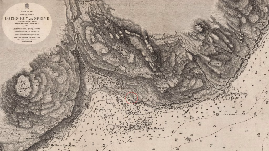
The Isle of Mull’s landscape features drama, jagged mountains, and sprawling lochs. Its coastline ranges from gentle sandy bays to towering, columnar cliffs. On the remote southern edge of the island, on the Ross of Mull peninsula, visitors find a historically significant coastal structure at the end of a long, single-track road: Carsaig Pier. The site brings together the human story, geological history, and cinematic heritage. It sits beneath some of the most spectacular scenery in Argyll.
The location is profoundly isolated; it sits immediately west of Loch Buie’s mouth. The approach road is a demanding, single-track route leading from the A849 near Pennyghael. Those who make the journey find an immediate sense of escape. They feel immersed in the island’s “raw, untamed beauty,” making the effort worthwhile.
The Foundations of 1850: A Purpose Built in Stone
Authorities recognized the early need for a reliable landing point in this challenging area. The approval for a breakwater at Carsaig in Mull came as early as 1847. Just three years later, workers completed the full pier structure in 1850.
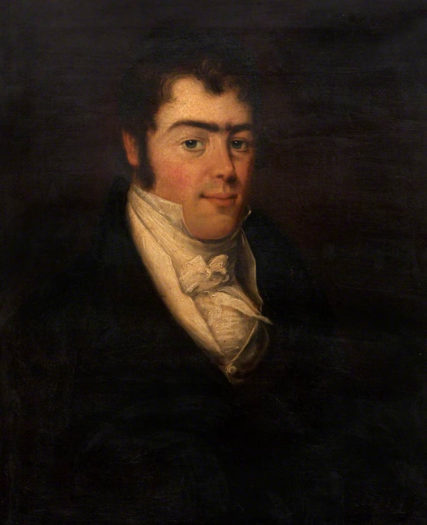
Joseph Mitchell, a prominent figure who shaped much of Scotland’s coastal infrastructure, oversaw this significant piece of civil engineering. Critically, the British Fisheries Commission (BFC) commissioned the structure. Therefore, the pier was not merely a private asset, but a state-sponsored initiative to formalize and boost the local economy. It primarily served local lobster fishermen, providing a crucial link between the remote island community and wider trade networks.
Carsaig Bay’s rugged nature makes it generally unsafe for watercraft. Only a small area sheltered by the island of Gamhnach Mhòr offers protection. The pier thus became an essential intervention. It transformed a naturally hostile environment into a functional port.
The Industrial Heartbeat: Stone for Sacred Ground
Fishing was the pier’s original mandate, but it quickly adopted a crucial secondary function: supporting the regional stone industry. Carsaig Pier became the essential export hub for Carsaig sandstone, a locally abundant geological resource. Workers quarried this yellowish-green stone near Rubh a’ Chromain, approximately two kilometers southwest of the pier.
The pier’s most significant industrial contribution directly tied into Scotland’s heritage. They specifically sought out and used the freestone quarried here during the major restoration of the Augustinian Nunnery on the sacred isle of Iona, across the Firth of Lorn. The restoration, which took place between 1874 and 1876, heavily relied on moving the material from the Carsaig Quarry to the pier.
Since boat or foot are the only ways to reach the quarry site, the pier became the sole point of marine departure. Workers loaded cut blocks of high-value, substantial stone onto vessels. They transported the material about 25 kilometers across the sea to Iona. This function critically supported the preservation of one of Scotland’s most historically important medieval sites. Architectural analysis suggests the Carsaig sandstone may also have been the original material source when the Nunnery was first constructed in the 12th century. This connection confirms the long-standing importance of Carsaig geology to Hebridean heritage, establishing the pier’s multi-functional importance.
Hollywood and the March of Decay
Following its industrial peak, Carsaig Pier experienced a gradual decline in commercial operations, mirroring broader Scottish macro-economic trends. Commercial fishing activity at the site, though historically strong, eventually ceased. This cessation likely occurred alongside the general decline of many remote, smaller ports in the 20th century.
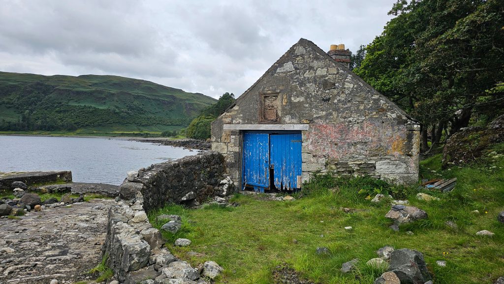
However, the pier’s story was far from over; it soon gained a new layer of cultural significance. Filmmakers chose Carsaig Pier as a key location for the beloved 1945 Michael Powell and Emeric Pressburger film, I know Where I’m Going!. The pier and its adjacent boathouses featured prominently in the movie, establishing a lasting link between the remote structure and cinematic history.
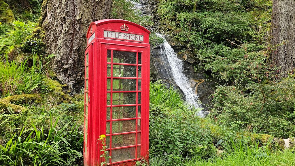
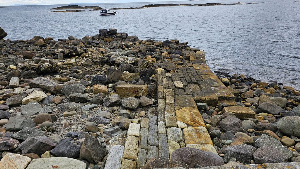
The cultural impact of the film is perhaps best exemplified by an ancillary structure located nearby: the telephone box on the road leading to Carsaig Bay. This humble telephone box, also seen in the film, was saved from destruction and has since been officially designated as a Category B Listed Building by Historic Scotland. This designation, secured because of its connection to a globally recognized movie, ensures its preservation as a tangible piece of heritage. Meanwhile, the original 1850 pier, despite its greater age and industrial importance, is universally described in contemporary reports as a “now crumbling structure” that is “in danger of complete collapse”.
Today, the overall structure is largely ruinous. Over time, a partial intervention appears to have taken place; observers note a “more recently constructed section of the pier,” protected by scattered original stone blocks. Technical assessments reveal a striking paradox: while the pier is failing, the original stone blocks found on the foreshore are in “surprisingly good condition.” The material beneath the thin weathered layer is generally hard and sound. This suggests the collapse is primarily an engineering failure, related to joints, foundations, or persistent coastal erosion, rather than a failure of the durable stone material originally chosen for the job.
The Adventurer’s Gateway
Formidable logistical constraints are inherent to the site. The narrow, demanding single-track road offers limited space for turning or parking heavy machinery. This means major structural remediation is highly challenging, if not prohibitive. For now, the elements largely determine the structure’s future.
Despite, or perhaps because of, its picturesque decay, Carsaig Pier has cemented a new 21st-century identity. Tourists now cherish it as a pivotal access point for nature, geology, and adventure.
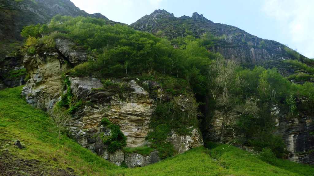
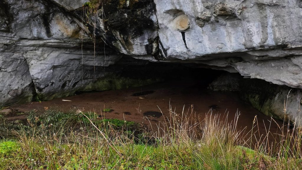
The parking area near the pier marks the start of a highly challenging, but deeply rewarding, coastal walk to the renowned Carsaig Arches and the historic Nun’s Cave. Hikers must wear sturdy footwear and strictly monitor tide times as they navigate the impressive, 700-foot basaltic cliffs. These cliffs formed approximately 60 million years ago during volcanic activity. The geological wonders include the massive “tunnel” arch and the striking “keyhole” arch, which pierces an isolated, high rock formation.
The area around the pier is a recognized wildlife haven; it sits within the South Mull Coast Site of Special Scientific Interest (SSSI). Visitors watch the clear waters and dramatic landscape for otters. Seals often bask on the skerries. The cliffs house a variety of nesting seabirds, and the area offers a prime spot for viewing wild goats and raptors, including Mull’s famous White-tailed Sea Eagles and Golden Eagles.
The old pier structure, though collapsing, maintains a quiet, recreational function. It offers a remote spot for sea fishing or simply enjoying a picnic while observing the rich marine ecosystem. The aestheticization of historical ruin means the structure, while critically endangered, paradoxically underpins the site’s modern appeal to adventure tourists as a derelict, isolated artifact.
Monument and Fate
Carsaig Pier is regarded not merely as a ruin but as a monument. It physically manifests a persistent challenge: balancing the high costs of preserving remote, 19th-century engineered structures against the aesthetic, ecological, and cultural value now attached to their rugged isolation and slow, inevitable decay. The structure’s current fate ensures the journey to Carsaig remains an unforgettable experience, a true immersion in the spectacular, untamed beauty of the Isle of Mull.
